If we want to create broad support for boosting the open space, the acquisition and dissemination of knowledge and insights alone does not suffice. We also need to try and form an appealing picture of this new future. This is why we combine our projects with research by design as a driving force for change.
In this case we find ourselves on relatively unknown territory. Architects and urban planners may well be familiar with research by design in inner city areas or in rural areas, but in places where urbanisation and the countryside converge new expertise and a new conceptual framework are necessary. What constitutes an ‘urban food landscape’ or a ‘water landscape’? How can we achieve a new balance between the urban system and the open space system? How can we shape both as a single cohesive metabolism? Which specific projects connect the different social services provided by the open space?
Climate change
In addition, over the past decade, a new theme has featured prominently on the agenda. A broad awareness has grown of climate change as one of the most threatening global developments for the next century. Climate change makes the transformation of our open space system urgent and necessary. The open space is the ultimate buffer that we can use to absorb and temper the consequences and effects of climate change. The open space is the key to making the territory more climate resilient, not only in Flanders but also in the Eurodelta and elsewhere in the world.
We were able to draw a great many lessons from the research by design. First of all, the complex mutual dependence between the city and the land came to light. The various social and spatial challenges and ambitions related to the climate, water systems, agriculture, forestry, industry, biodiversity development or housing construction are closely interwoven. This demands complex system thinking in which different areas of expertise will have to identify with one another and learn to speak a common language. It also means that extremely diverse stakeholders are involved: authorities at different levels, landowners, farmers, soil carers, civil society organisations, nature associations, water managers and so on.
At the same time we also unearthed the shortcomings of research by design. An appealing future vision cannot in itself initiate change. What we also need is a restructuring of policy and a search for new funding models.
Atelier Istanbul
What if the urban system radically bowed to the open space system? We tested this in 2012 on the occasion of the IABR 2012–MAKING CITY. We started work in Arnavutköy, the region slightly to the west of Istanbul. It is a region of great ecological value due to its many drinking water basins, forests and agricultural areas. Since the Nineties, this valuable region has been under threat from explosive population growth of at least 400%. Former mayor Erdogan launched ambitious plans to transform Arnavutköy into an important city centre on the European side of Istanbul. The region has to cope with the challenge of reconciling the planned growth with ecological values.
As Atelier master we invited the Brussels architectural firm 51N4E and the Dutch landscape architects from H+N+S to conduct research by design into the area together with a team of local experts. The designers produced two maps with, on the one hand, a scenario in which the current status quo is maintained, and on the other one in which there is the desired urban development. In the first scenario all ecologically valuable areas risked being swallowed up by the proliferation of urbanisation. The lakes disappear, which means Istanbul's water supply is threatened and the risk of flooding and pollution increases. The second map shows an alternative scenario: compact urban fabric with the natural landscape at its core. The scenario affords space for water in the low-lying areas, while a compact city retreats to the hilltops. In between, like a buffer between the city and nature, you find agricultural land parcels.
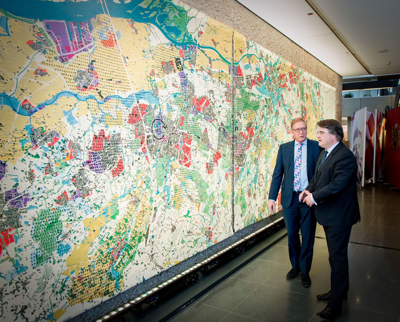
Carpet metropolis, Weaving the Urban Carpet
In the IABR–Atelier Brabantstad, during the sixth edition of the IABR 2014–URBAN BY NATURE, we conducted research by design in association with Lola Landscape architects and the architect Floris Alkemade into what Brabant locals rather aptly call the ‘mosaic metropolis’. In contrast to the usual planning logic we proposed not to concentrate spatial development in and around the five city centres. We took a different approach and explored how we could reorganise the widely dispersed urban landscape to produce a single cohesive system in which challenges and opportunities in the city centre are linked to the challenges in the outskirts.
One of the outcomes of the research by design was an alternative map of Noord-Brabant, which we literally wove like a tapestry, twelve by three metres. The carpet was first displayed at the IABR, and subsequently travelled through Brabant. The map shows a mishmash of intersecting patterns. It is not a classic destination map, but a map that defines 'recurring problems' or 'types of challenges' using a numerical code. The challenges are diverse and concern matters such as agriculture, forestry, water issues or industry. Identifying these kinds of links as recurring challenges offers the possibility of simultaneously initiating action in several places. This approach enables us to accelerate and multiply the desired action on the ground.
Double pole, Metropolitan Coastal Landscape
In the research by design for Metropolitan Coastal Landscape 2100 about the future of the Belgian coast, we strived to reverse the usual development logic, just like in Istanbul: what would it mean if the urban system adapted to afford space for water once more in a natural landscape? We drew up four future scenarios, of which the 'Double pole variant' may well be the most striking or controversial. According to this scenario the western half of the coast is largely returned to nature. During spring tide, storm surge or flooding from inland, large areas such as the IJzervlakte can flood. Veurne, Nieuwpoort or De Panne are still on the map, but are surrounded by water or marshland. This creates a landscape that is similar to the bay of the Somme in Northern France, offering space for nature and water tourism. In this scenario the eastern cluster around Ostend to Knokke and Bruges would be protected against rising sea levels and form one large, urban region.
The double pole scenario appeared in the newspapers even before the project had been completed. It caused quite a commotion. The result of the research by design was presented as a future plan that was going to be implemented. Of course, this was never the intention. The four future scenarios showed four extremes, allowing radical thinking which, in a later phase, around the discussion table, would evolve to reach common ground. Due to the publication of a single scenario the coastal mayors had no choice but to publicly distance themselves. As a result it became extremely difficult to shift towards a common denominator in the follow-up project.
Years later the image of the double pole was picked up by the producers of the Flemish-Dutch fictional series Als de Dijken Breken (If the dikes fail).The map appeared in the background as the desired future scenario after the outbreak of a new flood at the coast.
This anecdote teaches us that radical scenarios in themselves are not able to initiate change. The vision of the future is quickly dismissed as ‘fiction’. Research by design does not suffice on its own. We learned that designers should not only design, but that we should also challenge them to jointly shape processes. Not only the conception of the end result, but also how we achieve it, is a task for the design process.
Productive Landscape pilot projects (2013-2016)
Conserving the open space is not only the job of the authorities. Management of this collective good lies in the hands of a diverse group of open space caretakers, first and foremost farmers. Today, half of the open space in Flanders is allocated for agricultural production. Therefore, farmers are undeniably important stakeholders
In the Productive Landscape pilot projects, an initiative by the Flemish Government Architect and the Institute for Agricultural, Fisheries and Food Research (ILVO), for the first time farmers were given a voice, resources and a mandate to experiment with enhancing the open space. We were involved in both the preparatory and concluding work. We mapped out the problems and defined five urgent areas of work to which farmers, local authorities, businesses and landowners could subscribe. Each of the pilot projects was assigned a designer and an area director.
Not all the pilot projects were implemented. It soon became clear that the problems in the agricultural sector were more than purely design issues, and that fundamental policy changes were also needed. At the end of the pilot projects we were asked to bundle the main lessons learned. Together with the steering group we wrote a manifesto containing five urgent policy recommendations. One of the most significant conclusions of the project is that for the transformation of agriculture and the open space we not only need designers, but also ‘area directors’ or ‘food directors’. These are multidisciplinary experts that bring all the diverse actors around the table and build a bridge between policy, agriculture, citizens, ecology, climate, water management, soil care and urban development.
WaL World Map
Water is one of the most complex challenges, not only in Flanders, but all over the world, not least because water issues such as flooding, drought, pollution or salinization are often closely related to other global issues such as climate change, migration, population growth, pressure from urbanisation or the rising demand for food and energy.
If you look at the World at Risk map you see that the most densely populated places on earth (red) are also the places where water represents a major threat (blue). This is not surprising. Since time immemorial, people have settled in the fertile delta regions, where water is abundant and rich sediments provide fertile soil. The coastal and delta regions in Asia are predominantly red and blue. There is nowhere else in the world where water-related disasters are so widespread and costly as in Asia, where 83% of the population may be affected by flooding, the rise in sea level or overdrafting. However, it is precisely because water issues are closely linked to major global challenges that water is not only a problem, but also the key to finding a solution.
Design proposals that view water as a lever for urbanisation, could also be the solution to the difficulty of obtaining funding for water projects. This is the hypothesis tested by Water as Leverage for Resilient Cities: how can we use the water issue as a lever for the sustainable, integrated and fundable urban transformation of Asian coastal and delta cities?
In order to test this approach in the field, we set up a partnership with the Netherlands’ Water Ambassador, the Asian Infrastructure Investment Bank (AIIB) and three Asian metropolises: Chennai in India, Khulna in Bangladesh and Semarang in Indonesia. Together with the three cities we documented specific local issues. On this basis, in 2018, we launched a call for consortia of designers, engineers and advisers. The intensive design process that resulted, produced a number of innovative and transformative project proposals.
WaL harbours high ambitions: to implement integrated, fundable and locally-supported projects that proactively focus on climate change. This ambition still appeared to be too great for the strict procedures applied by international investment banks. Moreover, there was insufficient time to adequately develop local capacity building. Nevertheless, the power of the imagination and the innovative process of WaL, have set in motion an important cultural change by, for example, involving financiers at the beginning of the design process. As of 2020, we are involved once more in WaL_REFLECT, a partnership with the Netherlands’ Water Ambassador, the OECD and the University of Groningen. In this process we aim to convert innovation at the social, financial and design-oriented level into a structural partnership able to achieve ambitious implementation programmes. We are moving from research by design to change on the ground.